Ottawa River Showing First Signs of Relief
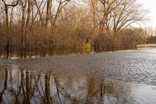
Ottawa residents and riverside communities can breathe a small sigh of relief this week: water levels on the Ottawa River have begun to tick downward, according to the Ottawa River Regulation Planning Board.
The decline — described as slight — is being observed at several points along the river between Pembroke, Ontario, and Carillon, Quebec, a stretch that covers much of the watershed that feeds directly into the capital region.
Why Levels Rose in the First Place
Every spring, the Ottawa River swells as snowmelt from across the vast watershed drains into tributaries and works its way downstream. This year's freshet — the seasonal spike in river flow caused by melting snow — pushed levels high enough to put communities along the shoreline on alert.
The planning board, which coordinates water releases across the river's network of dams and reservoirs, has been carefully managing outflows to reduce the downstream impact on low-lying areas. It's a delicate balancing act: release too much too fast and you flood communities downstream; hold back too much and you risk overwhelming storage capacity upstream.
What "Small Signs of Decline" Actually Means
It's worth tempering expectations. A slight decline in river levels doesn't mean the flood risk is over — it means the peak may have passed in some areas. Water levels can still remain elevated for days or even weeks before returning to normal seasonal ranges.
For residents along the Ottawa River shoreline — from communities in the Pontiac region on the Quebec side to areas in Renfrew County on the Ontario side — the message from water managers has been consistent: stay vigilant, keep an eye on updates, and don't assume the danger has fully passed just because the numbers are moving in the right direction.
Ottawa's Flood History Makes Every Spring Tense
For anyone who lived through the Ottawa River floods of 2017 and 2019, spring is never quite a carefree season. Those back-to-back flood events caused widespread damage to homes along the Quebec and Ontario shores and led to significant conversations about long-term flood mitigation infrastructure.
Since then, the planning board has worked to improve coordination across the watershed, and the province of Ontario and Quebec have invested in better monitoring tools. Still, the river remains a powerful natural system that doesn't always cooperate with human planning.
How to Stay Informed
If you live near the Ottawa River or are planning activities along its banks, a few resources are worth bookmarking:
- Ottawa River Regulation Planning Board — publishes regular water level and flow updates during high-water season
- National Capital Commission — issues advisories when riverside trails and parkways are affected
- City of Ottawa — provides local flood risk information and updates for affected neighbourhoods
The situation is expected to continue improving as temperatures stabilize and the snowmelt season winds down, but water managers will be watching closely over the coming days.
Source: CBC Ottawa